 |
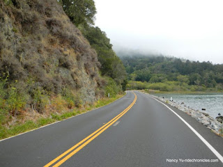
| View of Marion Road. Thanks to Nancy Yu for sharing her great photos. You can see more of her work at RideChronicles.com |
As we arrived to Panoramic Hwy the fog was getting pretty thick. While on the first part of Panoramic there were a number of places where the trees were so damp from fog/drizzle that water fell down from them like rain. Not at all what I was expecting and I started wondering if I had brought enough clothes to keep warm. About half way along the highway, however, the sun not only came out, but it began to get hot.
We had a break/regroup listed for the Pan Toll ranger station. I've never been to the ranger station and didn't even realize that there was one there off to the left of the highway, so I missed the regroup. Other people obviously knew it, but I followed the directions that said bear right on Pan Toll. The climb up Pan Toll was pretty hot, but it was clear that there was some significant fog at the beach well below.
 |
| Bolinas lagoon as seen from highway 1. Thanks to Nancy Yu for this photo. |
We followed West Ridgecrest Road and then went down Fairfax-Bolinas Road to Bolinas. I've always taken the road in the other direction (also downhill, initially, to Fairfax). Now that I have been both ways, I prefer the dam side for fun down hill riding. Anyway, after about 2 miles of going down hill, we arrived at Highway 1 and turned left (south) to go to Stinson Beach. Although there was blue sky on the way down to Bolinas, the temperature was dropping and as soon as we headed toward Stinson, the fog returned.
 |
| This sign comes at the end of Fairfax-Bolinas Road on the Bolinas side. As you can see, the sky is blue. Trying to find this road from highway 1 can be difficult as all signs posted get removed by residents. See the Wikipedia post for more about that: https://en.wikipedia.org/wiki/Bolinas,_California |
 |
| Seaside themed fence in Stinson Beach. |
 |
| We had a picnic lunch at the beach. |
We had our lunch break at the beach picnic area. There was quite a lot of people at the beach for a weekday. Perhaps many were trying to get out of the heat in other places? Summer vacation in effect? after the lunch break, we returned to highway 1 and continued south. There is some climbing after leaving the beach. It doesn't look that bad on the elevation profile on the computer, but in real life, it felt like more than what the profile shows. After the initial climbing, there is some down hill and small rolling hills followed by one last climb after passing Muir Beach.
 |
| View down to the ocean in the fog. Thanks to Nancy Yu for this photo. |
 |
| Highway 1 in the fog after leaving Stinson Beach. Thanks to Nancy Yu for this photo. |
The fog was still present, but we were heading inland at that point. It was great to have cooler temperatures for the climb up. After reaching the top of the climb and heading down again, the sun came back out and it was basically all down hill to Mill Valley. The mileage was a little less than I thought it would be, so I did about 5 more miles around Mill Valley before returning to the car and heading home.
Stats:
39.84 miles
3,649 feet of elevation gain
No comments:
Post a Comment