Monday, July 27, 2015

Mountain biking 7/25: North Sonoma Mountain Ridge

I joined John and two of his regular mountain biking pals Chris and Pete try some trails at a park none of us had visited before. Chris drove us all up to Glen Ellen where we took Sonoma Mountain Road. It is a narrow, somewhat winding road with a mix of fancy homes and farms/ranches here and there.  I've ridden my road bike up that road, but it has been a while and I had no memory of seeing the park we were headed for.

Eventually we found the sign to turn and headed down that even smaller road, part of which was gravel.  At the end was a nice trail head.  We took North Sonoma Mountain Ridge trail, having no idea what to expect except that we were going to ride to the end of the trail, about 8 miles and then turn around and come back.

The trail started by going down, which, while fun, I really dislike, because that means that at the very end I'll have to climb to get to the car.  After the intital bit going down, we started climbing.  The first part of the trail had a fair amount of hairpin turns and hikers.  It was fairly warm, but not unmanageable, in part due to plenty of shade.  I could feel all the 90 miles from earlier in the week in my legs.  I could tell I wouldn't have much power.

View from a look out point early in the ride


Resting in the shade.


After continuing on the first trail for about 2 miles we crossed the park boundary into Jack London State Historic Park. We continued on the trail, primarily climbing.  There was very little flat or down hill. We moved on to Hayfields Trail and then on to Mountain Trail, also all primarily going up.  I'm not sure which it was of these, but I stopped and had some blackberries from bushes that were growing wild.  They were good, but not much to each one.
At the boundary for the two parks. Jack London State Park lies ahead and North Sonoma Mountain behind.

 The last trail we took, Sonoma Ridge Trail, was fairly short and came to a dead end. The surrounding land was privately owned.  The terrain was mostly rolling on this trail. 

Our return had lots of down hill, which was good for me because I was getting quite tired, but it also went up, too.  We came to a steep fire road with a fair amount of loose rock and soil.  When we went down it earlier in the day, I knew it would be very hard for me to go up it.  I was right.  I didn't have enough power in my tired legs to do it and had to walk most of  the way, pushing my bike. When I got closer to the others 
(who were waiting on a bench at the top), John came down and helped me by pushing my bike up for me.  It might not seem that like would make much of a difference, but it did.   

Because we were able to go down hill for most of the return, I did okay, but did have to do a little more walking at another uphill with loose dirt and rock.  Obstacles and moving soil need a lot more power to climb than smooth, packed soil. 

I expected to see a lot of hikers again as we neared the parking lot and trailhead, but there were only a few.  We felt a nice cool breeze on the trails on the return, but out it the open areas and at the parking lot it was blowing strongly.

The climb at the end that I was dreading (even more so given how tired my legs were) turned out to be a non-issue.  The slope up was so slight as to not be a problem at all.  Thankfully.
Bikes in the truck, ready to go home.
Stats:
16.01 miles
2,876 feet of elevation gain
Map of the park:
http://www.access4bikes.com/wp-content/uploads/2015/06/SonomaMtnRT-AAT.pdf

Friday, July 24, 2015

Training Ride 7/24: Three Bears

It is my training goal to get in 130 miles per week until time to leave for the bike tour down the Oregon coast.  To hit that goal this week, I made a last minute decision to do a short ride by myself; I didn't have other plans on Friday afternoon and knew I would likely  fall short otherwise.

After lunch I started riding right out my front door and headed out to do the "Three Bears."  I road through El Cerrito and Richmond to San Pablo Dam Road (SPDR).  There was a lot of traffic and some contruction on SPDR, which made some of the worst traffic conditions I've experienced on that road.  It was a relief to turn off on to Castro Ranch Road.

By the time I got to the bottom of Castro Ranch and over to Alhambra Valley Road, I could feel the temperature going up.  I was concerned that the clothing I had chosen that would be too warm, especially on the climbing, but it turned out to be about right.  I enjoyed turning on to Bear Creek Road, knowing that I wouldn't have to climb Pig Farm Hill again (yet).   

This stretch of Castro Ranch is full of all these crazy tire tracks.  A lot of people must come out here to try all the driving stunts they see in movies.  A lot of people also dump garbage on this road.  It is really a shame.

 Thanks to the folks at the cemetery who let me use their restroom so I didn't have to go in the bushes or wait through most of the climbing.

Bear Creek Road fruit stand sign.
There are "three" bears (hills) to climb on Bear Creek Road, however, because of false tops, it feels like more.  The first is mama, then baby, and last is papa.  After papa, it is all down hill back to SPDR except for the very end where there is an unpleasant little hill.  It is very short, but pretty steep.  It feels a bit unfair in that location.

I crossed SPDR and went up Wildcat Drive to get back home.  There was a pleasant breeze on Wildcat, especially above El Toyonal.  I did a quick spin around the parking circle at Inspiration Point to look at the view back toward the reservoir and then continued to Grizzly Peak where I went through Kensington to 
go home.

Inspiration Point sign.
 Stats:
31.70 miles
2,562 feet of elevation gain

Training ride 7/22: Ride around the peninsula/south bay

I met my friend Debra very early for this ride.  We don't live very close to each other and trying to find a place to ride that is a reasonable distance for us to both travel to is sometime challenging in the summer.  To beat the gnarly Bay Area commute traffic we agreed to get up and at them early, a task more challenging for me than her.  I am not a morning person.  Debra and I met at the arthritis training group rides in 2013 when we were both getting ready for the SF to LA ride.  

We were pretty successful in not getting stuck in traffic.  We met at Canada Drive and Edgewood Road in Woodside. From there we went down Canada to get to King's Mountain Road.  We went up King's Mountain.  It was nice to be on the road on a weekday with very little traffic.  Despite starting up it at about 7:30 in the morning, it was a hot and sweaty climb the while 5 miles up to Skyline Blvd.

At the top, I noticed that Skyline was some kind of weather dividing line.  Warm and sunny on one side and fog coming up the other.  We crossed it, had a brief pause to put on arm warmers, and then we went down hill. The name changes to Tunitas Creek Road on the other side of Skyline. I've always been up Tunitas Creek, never down, and have wondered what it would be like to go the other way.  Now I know.  While it was grey and cold on the way down, it was also a really fun ride.  It was 3 miles of swoopy road with almost no traffic of any kind to the Bike Hut where we regrouped. 

Chickens across from the Bike Hut.  I have never noticed them before.

My fingers were very cold at end at that point, so it was good to stop for a few minutes.  After the break, we continued to the end of the road and then went about 1.5 miles on highway 1 to Stage Road.  We turned down Stage to the town of San Gregorio and then headed up highway 84 (La Honda Road). 

We continued on La Honda until veering right on to Old La Honda Road.  I've always been down this part of Old La Honda, never up. I envisioned it being a really tough climb because of how fast you can go down, but it was only moderate, had great scenery, and no car traffic at all.  It was a treat.  

At Skyline, we turned down toward Alice's Restaurant to reconnect to highway 84, which we took to Portola Valley. In Portola Valley we stopped for lunch at Robert's Market.  From there we took Atrascadero to Foothill Expressway.  While we were pedaling toward Sand Hill Road, we noticed a tandem bike on the other side of the road that looked familiar.  It turned out to be friends of ours, Bill and Gail.  They were on their way home from a week and a half trip down northern California on their tandem.  What a coincidence to be in the same place at the same time!  They were riding all the way to their house with about another 20 miles to go, but had their sights set on a ice cream before getting there.

After seeing Bill and Gail, we continued and then went up Sand Hill Road. Sand Hill has mild climbing and a wide shoulder, which is great until you come to the part with all the freeway exits and entrances.  It can get pretty tricky in that segment.  Once past that, it is pretty much down hill all the way to Manzanita, then Mountain Home, and a return to Canada.

All that by 2:15 pm!
Time to load up to beat the traffic back home.  Unfortunately, I didn't quite beat it on 880 and 80, but it could have been worse.

Stats:
61.61 miles
5,476 feet of elevation gain (Debra loves to climb)

Mountain biking 7/20: China Camp

I joined two friends of John's, Chris and Adam, for a loop around the front side of China Camp State Park.  John mountain bikes regularly with Chris.  This was Adam's first mountain bike ride. 

It was a warm day, but it turned out to be not too hot due to a cooling breeze that came up.  I had filled my hydration pack with two trays of ice cubes, expecting HOT temperatures, but luckily it wasn't that bad.

The route we take starts at the entrance to Miwok Meadows.  That provides a good warm up before beginning climbing.  There is one main climb that covers about 2 miles.

Because it was a weekday, it was very quiet in the park.  We did happen to see two electric recumbent bikes along the way.  I've never seen bikes like that, even on the road, much less off road.

The climbing was challenging for Adam.  I could really empathize.  The first time I went to China Camp was early in my path of taking up cycling as an adult, so I was not very fit; it was also a warm day.  I had to stop over and over on the trail to rest before I could get to the top of the climb.  

After the main climbing is finished, the trail is mostly down or rolling, with a few flat spots.  

View of Peacock Gap and out to the bay from China Camp.


Stats:
9.04 miles
990 feet elevation gain (but I could swear Gamin gave me a different number in the past for the same route)

Hybrid ride 7/19: Wildcat-Tilden

It was hot and humid, so John and I didn't leave the house for this ride until about 5 pm.  We took our mountain bikes, but headed out on the road.  We followed the Ohlone Greenway multiuser trail to Key and McDonald in Richmond and then city streets over to Wildcat Canyon Regional Park, about 5 miles.  There was some steep climbing at the end before entering the park. 

Once in the park, we continued on the main trail, Wildcat Creek Trail (the one that used to be a road, but has been "abandoned" for many years and is returning to nature) for a short distance to the start of the Havey Canyon trail.  Havey Canyon is a narrow trail that mostly climbs through trees and shrubs.  There are a couple of gates to go through and one stream to cross.  The entrance and exit to the steam are very steep without much room to maneuver, so we walked it.

Entrance to Havey Canyon Trail.

John closing one of the gates after we went through.

At the top of the trail, it connects to the paved Nimitz Way trail.  We took Nimitz across park boundaries into Tilden Park. Along the way we saw, cows, rabbits and various birds.  Nimitz is the trail that begins at Inspiration Point.  We exited the trail at Inspiration Point and took a right on to Wildcat Drive.  We rode a very short distance to Seaview Trail on the opposite side of the road.


View from Nimitz Way.

Seaview starts by climbing up to a ridge.  (The trail seems to change names to East Bay Skyline Regional Trail and then again to Bay Bay Ridge Trail.)  There were some good views from the ridge.  We also got a very small amount of rain.  After a while, it was starting to get dark, so we decided we better hurry up and head home.  We took Upper Big Springs Trail downhill to South Park Drive. 
View from Seaview Trail.

We got on the road and went a short way down to the intersection with Wildcat Drive.  We pulled off to the side of the road and put lights on the bikes.  We continued on Wildcat toward Grizzly Peak Blvd, then headed down Spruce and through Kensington to get home via paved roads.

Stats:
19.7 miles
1,748 feet elevation gain

Park maps:
Tilden: http://www.ebparks.org/Assets/_Nav_Categories/Parks/Maps/Tilden+map.pdf
Wildcat: http://www.ebparks.org/Assets/_Nav_Categories/Parks/Maps/Wildcat+map.pdf.pdf

Tuesday, July 21, 2015

Training Ride 7/15: Duncans Mills to Fort Ross

I debated about going on this Wednesday ride because of the distance to the starting point.  Duncans Mills is on highway 116 between Jenner and Guerneville.  Luckily, I was able to get a ride from Sandy.  It is good to have company on a long drive.

It was cold and windy with a hint of fog at the start.  Before we took off, some park rangers came by and asked about our route.  They said there was fog at the coast.  I was hopeful that it would burn off by the time we got there, however, it was good to be somewhere that wasn't too hot.  Many places were experiencing some pretty warm temperatures.  I rode off with both leg and arm warmers on and a jacket in my bag due to the wind.  I know I tend to over-dress, but the amount of clothes seemed reasonable given the conditions.

However, within a few miles we were on the Cazadero Highway, the sun was shining, no fog at all, and the temperature was going up.  It was a nice ride through town, but there was more traffic than I would have thought on a weekday.  

When we got to the small business area of Cazadero, many of us stopped to take a layer (or more) off.  I didn't know the route at all, so I had no idea what was coming next.  As it turned out, we were about to start climbing up Fort Ross Road, so I am glad I took off both the arm and leg warmers at that time!  

The temp continued to go up and I'm not good in the heat.  Living right on the bay, I'm used to cool summer time temps.  The start of the climb was a very steep "wall."  After about a half to 3/4 of a mile we settled into a less steep grade.  We climbed for about 5 miles before reaching the first summit.  About a half mile from the top (although I didn't know that at the time), I had to stop and take a break in the shade.  It was really warm.

Fortunately, there was very little traffic along Ft. Ross Rd.  It is much nicer to climb without cars zipping by all the time.  

From the first summit, there was some fun down hill, but the a steep climb up again for the start of the second summit.  This one also leveled off after a while.  Total climbing here was about 2 miles.  After that, there was some gently rolling hills, most of that was on Seaview Rd.  At this point we were on a ridge and started to experience the marine influence from the coast.  When we turned left on to Timber Creek Road, we got to go down hill, at times up to 18% grade.  It was a great bit, but relatively short; about 1.5 miles to highway 1.

We turned left (south) and went a short distance down the highway to the Fort Ross Store where we stopped for a lunch break.  When we sat down at the picnic tables on the back deck there were some CalTrans workers also having lunch who were surprisingly knowledgeable about the status of the Tour de France and all the racers.  It was somewhat cool and foggy.  The fog seemed to be acting like an insulator, so it wasn't that cold.  In fact, if I got out of the wind, it was surprisingly warm.  

I was feeling pretty hungry by this time, so I was happy to take a break.  I had a sandwich with me, but I got some chocolate milk at the store.  I haven't had chocolate milk in a long time and was surprised at how delicious it was.  Chocolate milk is reputed to be a great sports recovery drink.  (Why is chocolate milk a good recovery drink?  "Compared to plain milk, water, or most sports drinks, it has double the carbohydrate and protein content, perfect for replenishing tired muscles. Its high water content replaces fluids lost as sweat, preventing dehydration. Plus it packs a nutritional bonus of calcium, and includes just a little sodium and sugar — additives that help recovering athletes retain water and regain energy."  From http://www.fitnessmagazine.com/recipes/healthy-eating/superfoods/chocolate-milk-after-workout/)

A group of us arrived at the store together, but other folks on this ride were somewhat spread out on the road.  Most of those took the short cut down Meyers Grade Road, bypassing Fort Ross and cutting off about 16 miles. Those of us at the store waited for our ride leader, Phil, who had been at the back staying with the riders who were feeling overly challenged by the climb.
Lunch on the deck at the Fort Ross Store.

After Phil had his lunch, we continued down highway 1 over rolling hills, a few steep, but not too bad compared to what we had been doing before lunch!  There was also some fun twisting and turning on the down sides.  Below the junction with Meyers Grade, we met up with the riders who had bypassed Fort Ross at a roadside cafe.  Looked like some good baked treats, but I was still full from lunch.
The cafe where we met the other riders.

The sun came out again as we left Jenner and turned back on to highway 116 to return to Duncans Mills.

Stats:
42.13 miles
4,083 feet elevation gain
 

Monday, July 20, 2015

Training Ride 7/11: Second Saturday Club Ride

Every second Saturday of the month (except May) the Grizzly Peak Cyclists have their all-club ride, the ASSR.  All club members and other interested parties are welcome.  There are five different groups that go varying distances and at various paces. All start together at the Orinda BART station and move at social pace along San Pablo Dam Road to Castro Ranch Road.
The Marin fountain.  I passed by here on my way to get to the BART station.

I have to admit that I've only been on the ride one other time about a year ago.  At that time, I joined the Allegreto group (65 miles), but the pace was challenging for me and I was pretty whipped at the end.  I felt slightly under-trained for that group, so I joined the Adagio group for 50 miles and a slower pace, but I did want to get in more miles, so I rode over to the BART station from home.

After regrouping at small parking lot on Castro Ranch Rd (at San Pablo Dam Rd.), we continued in our various paced groups.  My group headed over Pig Farm Hill.  Yes, Pig Farm Hill twice in one week even though I'm not a fan.  Why did I make this decision?  Honestly, it is as simple as the fact that I didn't know what the route would be since I only did this ride once.

Another hard climb up, another great ride down to Reliez Valley Road.  The sometimes open golf course on Grayson was open, so we stopped there for a break and regroup.  We made our way to Olympic Blvd and then a turn at Newell to get on to the residential streets and over to Danville Blvd.  We continued as far as Danville's downtown and stopped at Peet's for a beverage and a break.
Outside Peets.

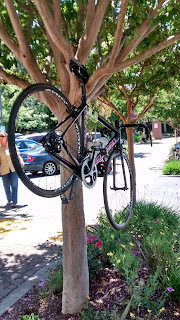
 I have only been at this Peet's a handful of times, but every time it is full of cyclists outside and fairly quiet inside.  It was no exception today.  The bike racks were full, as were any surface a bike could be leaned against and a few unusual places as well, like in the trees and hanging from light fixtures.  We relaxed for a while in the sun, had lunch, and chatted.  We had nice moderate temperatures with a mile breeze.

One of the alternative spots bikes got parked.
We returned on a similar route, but briefly took the Lafayette-Moraga Regional Trail and then moved on to Happy Valley Road.  I forgot how much climbing there is on that road.   We turned down Sundown and then took some residential streets back to SPDR and a short hop back to the BART station.  After that I returned home via Wildcat with Sherrie.

Stats:
72.56 miles
4,241 feet of elevation gain
www.grizz.org


Sunday, July 19, 2015

Training Ride 7/'8: Pinole to Martinez

The Wednesday ride was leaving from Pinole Valley Park on Pinole Valley Rd.  I decided to ride over from home.  I took a route through El Cerrito and Richmond to San Pablo Dam Road and then over to Castro Ranch Rd.  I went over the hill and into Pinole.  I gave myself plenty of time to get to the park, since I wasn't sure how long it would take.  I ended up being pretty early and we left a bit late, so there was about an hour before starting the group ride.  

From the park, we went back the way I came, but took Alhambra Valley Road and went over Pig Farm hill.  This one isn't one of my favorites, but it is good training, right?  At the top of the hill were some other riders who had come from Orinda BART and met us.  Although the climb up is one that makes me a bit cranky, the down hill side is great!  It is about 5 miles from the top to Alhambra Avenue, hardly needing to turn the pedals.  We continued on Alhambra into downtown Martinez.  

We had an early lunch break in downtown at the Alhambra Creek Plaza.  After a nice break with some sunny, but not too hot weather, we headed through a residential area to get on to the Carquinez Scenic Drive/George Miller Trail.  This was the first time that I have been along the whole trail and the first time that I have been on any part of it since the intensive repairs were completed to restore it.  (1.7 miles have been restored are gated and closed to car traffic.  More about the trail and restoration: http://www.contracostatimes.com/contra-costa-times/ci_26839614/scenic-trail-along-carquinez-strait-re-open-route.)

There are great views all along the road/trail.  It rolls and climbs along the length of it, even when back on to road.  Although the road is shared with cars, traffic is light in the area.  We passed the Bull Valley Staging Area at Carquinez Strait Shoreline Park.  A good spot for a break or a hike.

View from the trail.

Coming to the end of the George Miller Trail.  That's me in the back.  Thanks to Nancy Yu for sharing her photos.  You can see more of her photos at ridechronicles.com
We continued along the road, with a brief scenic detour to stay near the shore, and then into Crockett.  We exited town, went past the refinery, and then went through Rodeo and Hercules, primarily on San Pablo Avenue, before arriving in the old part of Pinole.  I've been on these roads, but always in the other direction.  Too bad we had quite a head wind today.

We returned to the park via Pinole Valley Rd. for the end of the group ride. After a break to say good bye, a small group of  us continued back over Castro Ranch Rd, San Pablo Dam Road, and then Wildcat Drive to return home.  There were some significant head winds continuing during this section.  However, after getting into Tilden Park, the wind did stop.  At the corner of Grizzly Peak and Wildcat, I set off by myself to go home through Kensington, Albany and El Cerrito.

That's my bike in the back.

Michael, Nancy and Phil at the end of the group ride in Pinole.

 Stats:
60.54 miles total
3,759 feet of elevation gain

Tuesday, July 14, 2015

Training Ride: 7/4 Sausalito to Mt. Tam

Although we don't usually have training rides on long weekends, there was one scheduled for July 4, so I decided to take advantage of it.  Besides, this is a nice ride.

The group actually started at Chrissy Field in San Francisco and rode across the Golden Gate Bridge, but I just couldn't bring myself to drive over there on a holiday, especially one where there will be people coming to Chrissy Field for fireworks.  Also, the tourist traffic walking and riding rental bikes across the bridge is always ridiculously high on summer weekends.  

I met the group in Sausalito at the bike path next to Mike's Bikes. We continued on the trail a short way and then through town to Mill Valley. We started climbing on Marion Ave. and continued to Panoramic Hwy.  Marion is a very quiet, twisting residential street with plenty of redwood trees and shade.  It is one of my favorite climbs. 

On Panoramic Highway, there is some climbing and rolling hills. In places it is narrow and traffic can be a drag.  We regrouped at the Bootjack campground, except Bob.  He must have gone right by this stop without noticing us.  It was getting warm at this point, so it was good to have a break and get some water before the climb up Pan Toll Road.  

In my mind, the climb up Pan Toll was terrible and 100% hot and exposed, but it turned out to be not so bad and only exposed toward the end.  The distance is also not as much as I thought, only about 1.5 miles to W. Ridgecrest Blvd.  When we turned on to Pan Toll Rd. we officially entered Mt. Tamalpias State Park.  
Mt. Tam sign.

There is a lot of talk about micro-climates in the Bay Area.  During this ride, I think we experienced all the possible climate varieties that exist.  Although, it was quite warm up Pan Toll, to the west we could see the coast socked in with fog and feel the occasional ocean-influenced breeze coming our way.  It a few places, ribbons of fog were trying to make their way inland without much success.
It may be hard to tell in this photo, but at the horizon is the fog from the coast.  This is looking down from the top of Pan Toll Rd.

We did not summit the mountain, but turned left and took W. Ridgecrest Blvd.  In this direction, it is mostly rolling hills and, with good timing, you can use momentum to get over most of the uphill sides.  You start out being on an open windy ridge top with grasses and some brush and trees to moving into a redwood forest that is deeply shaded and somewhat damp. 


Forested area at Fairfax-Bolinas Rd at W. Ridgecrest Blvd.  Can you see the cyclist in the lower right corner?

At the intersection with Fairfax-Bolinas Road we went down hill to Alpine Dam toward Fairfax.  I love to go down hill (the best reward for tough climbing is a good down hill) so this was a treat, especially because I didn't encounter any cars at all until I reached the dam.

View at Alpine Dam

From the dam, it is a fair bit of climbing to get to Fairfax, but not exclusively; there are some rolling hills and  down hill, especially the last 3.5 miles.  During a lot of the climbing section, there is a pretty good amount of shade, but toward the end it is hot and exposed and not nearly as scenic as lower down.  I was thinking a lot of some kind of coffee blender drink at the Coffee Roastery when I got downhill and into town.

Shortly after I arrived at the roastery, Bob found me and we both got blender drinks and sat in the shade.  Soon the rest of the group joined us and we had our lunch break there.  The roastery is an independent coffee house that is cyclist-friendly.  (I'd list their website, but they don't seem to have one.  If you want to find it, it is at the corner of Fairfax-Bolinas Rd and Broadway Blvd. in down town.)


After the lunch break, we returned through San Anselmo, Ross, Corte Madera, etc. In Corte Madera we went over Camino Alto and got back on the bike trail.

Stats:
36.28 miles
3,093 feet of elevation gain

Training Ride 7/1: Nicasio to Drakes Beach

Now that summer vacation is here, I have been able to join the regular Wednesday morning ride on the Grizzly Peak Cyclists schedule.

We started at the ball field in Nicasio, then headed out on Nicasio Valley Rd. and over to Platform Bridge Rd, then over the Olema hill.  It was a good day to be cycling in West Marin (where temperatures are usually cool or moderate) because it was forecasted to be over 100 degrees in many in the valleys and 80s and 90s elsewhere.
Here we are getting ready to take off.  There was a large group on this ride.  Thanks to Nancy Yu for sharing her photographs.  You can see more of her photos and read her blog at RideChronicles.com
After the Olema hill we turned on to Bear Valley Rd. and continued until it ran into to Sir Francis Drake Blvd. in Inverness Park.  We continued on Sir Francis Drake to the Y near the end of the road.  We took the left to go to Drakes Beach.  The tule elk were out, but too far in the distance for any pictures.  Drakes Beach is part of the Point Reyes National Seashore.  You can read more about it and other beaches that are part of the national seashore at http://www.nps.gov/pore/planyourvisit/beaches.htm.

Lunch break at Drakes Beach.  A cool breeze was blowing. Photo by Nancy Yu

View from the picnic area at Drakes Beach.  Photo by Nancy Yu.


We returned the way we came on Sir Francis Drake Blvd.  Not far from Drakes Beach, I stopped at North Beach at the suggestion of Bob Hallet.  Bob knows his birds and spotted a bald eagle on our way back to Drake Blvd. after visiting the small beach.


North Beach.  It was cool and windy at Drakes Beach, but surprisingly warm at North Beach, not far away.

Cows from one of the ranches that line Sir Francis Drake Blvd.

View down Sir Francis Drake Blvd.  Photo from Mark Sapiro.

In Inverness Park, we continue on Sir Francis Drake Blvd. and at the T, make a left turn on to highway 1 to go into Point Reyes Station and have a break at the Bovine Bakery. 
Entrance to Bovine Bakery.  They have all kinds of yummy treats!
The break in Pt. Reyes Station was very pleasant.  The temperature was warmer than usual there but not too hot.  From Pt. Reyes Station we returned to Nicasio via the Pt. Reyes-Petaluma Highway.  It was hot near the reservoir and into Nicasio.  It was a good day to be near the beach.

Stats:
55.28 miles
2,483 feet of elevation gain

Thursday, July 9, 2015

Training Ride 6/28 Redwood & Joaquin Miller Parks

John and I joined John's friend Chris for a mountain bike ride in Redwood Regional and Joaquin Miller parks in Oakland. We started out on the West Ridge trail and then dropped into Joaquin Miller near the Chabot Science Center.  After going down the Cinderella trail, one I find challenging, Chris some how got a moderate size branch by the side of the road caught up in this rear spokes, which then caused a flat.

The tubeless tire wasn't holding air (likely too little goo inside the tire), but he eventually resolved it by putting a tube in.  It worked for the remainder of the ride.

There were quite a lot of trail users out.  Our path crossed a group of what appeared to be cyclo-cross* riders.

I had my best performance on Big Trees trail ever.  I have never been able to get over all the obstacles without multiple tries on at least some of them, until today.

Unfortunately, my leg injury had been nagging me since the Bearclaw ride, and it was starting to flare up when we returned to Redwood, so instead of a loop around there (with a lot of climbing), we decided to call it a day and return to the car.

Stats (from Chris's Garmin, since I forgot mine):
9.17 miles
1,438 feet of elevation gain

*What is cyclo-cross?  Definitions usually focus on the racing aspect of the sport (such as what follows from Wikipedia), but like all forms of cycling, it can be done in a recreational manner. "Cyclo-cross has some obvious parallels with mountain bike racing, cross-country cycling and criterium racing. Cyclo-cross bicycles are similar to road racing bicycles: lightweight, with narrow tires and drop handlebars. They are typically differentiated by their greater tyre clearances, lower gearing, stronger frames, cantilever brakes and more upright riding position. They also share characteristics with mountain bicycles in that they utilize knobby tread tires for traction and, increasingly, disc brakes. They have to be lightweight because competitors need to carry their bicycle to overcome barriers or slopes too steep to climb in the saddle."

Mountain biking 6/27

Today, John and I led a ride around the front side of China Camp for a small group of rides from the California Deaf Wheelers (CDW). 
Entrance gate for the ride.
Near the start of the ride.

It was a nice day for a ride.  One short section was closed due to trail improvements, but it was easy to bypass with a fire road climb. 

It was also a lucky day because at the first bridge we saw an owl.  I don't know much about any kind of bird, but we believe that it was young because of its downy feathers.  I was very surprised that it out during the day time and further surprised that it was not disturbed by the many people stopping to take a look at it.


No other surprises for the remainder of the ride, but it was fun.

Stats:
9.06 miles
1,080 feet of elevation gain

Training Ride 6/20 El Cerrito to Bearclaw Ride and back

I rode from my house in El Cerrito to the Orinda BART station to meet a group of Grizzly Peak Cyclists for the Bearclaw Bakery ride.  I wasn't sure how much time to allow for the ride to the BART station from home, so I planned a comfortable amount of time plus a little cushion when I set my alarm the night before.  It was too bad that I didn't also turn on the alarm.  I woke up quite late, almost time to leave the house.  I scrambled around and was out the door a little late but not too much so.

My route took me up Spruce, over and down Wildcat Drive and then a short distance on San Pablo Dam Rd to the BART station.  Fortunately, the ride didn't take as long as I planned for, so I arrived to meet the group in plenty of time.

The ride to the Bearclaw Bakery is a monthly social ride offered by the Grizzly Peak Cyclist club.  The pace is mellow and there is a long break at the bakery to enjoy a treat before returning.  The ride goes along San Pablo Dam Road, over Castro Ranch, and then along Pinole Valley Road to the historic old downtown Pinole.  Around and behind the bakery are murals with local historical events and figures.

After the break at the bakery, we returned the way we came.  At Wildcat Drive, I returned back over the hill to go home.

Stats:
45.71 miles
2,958 feet elevation gain

Training Ride 6/14 Tamarancho Mountain Biking

John, Chris, Doug, and I did a mountain bike ride Tamarancho in Fairfax.  We started in our usual spot, which is at the end of a cul de sac where White Hill Middle School is.  There is a trail head right there for Marin open space land.  After about 3.5 miles on mostly fire road we entered Tamarancho property.

Tamarancho is private property owed by the Boy Scouts which sells passes to mountain bikers to maintain the property.  The local boy scouts have a camp site on the property and use it for their events.  There is a link to a map of the trails at this webpage: http://www.boyscouts-marin.org/event/fot-2014-day-pass/1456466.  Most single track* trails in Marin are illegal to mountain bikes, so Tamarancho is a welcome exception.
*"Single track or singletrack is a narrow mountain biking trail that is approximately the width of the bike. It contrasts with double track or fire road which is wide enough for four-wheeled off-road vehicles." from Wikipedia.

My legs were tired from the long road ride the day before, so I didn't have much power to get over the obstacles.  It also wasn't a very good day for hairpin turns, but overall, it was a good day out.

 http://ridewithgps.com/routes/9187138

Stats:
13.82 miles
1,873 feet elevation gain


Tuesday, July 7, 2015

Training Ride 6/13 San Mateo-Woodside-Pescadero-Half Moon Bay-return

The training group for the Arthritis Foundation rides met at Canada Rd and highway 92.  That spot is on a bit of a ridge, so you can really feel the wind blowing and since it was about 8 am, it was kind of cold.  We continued into Woodside where it was quite a lot warmer and I had to stop and take off my extra layer of clothes I put on when the wind was blowing at the start.  
 
Here I am with Mary Arnone near the beginning of the ride.  She will be riding the California Coast Classic this year shortly after I finish the People's Coast Classic.


It felt even warmer when we started climbing Old La Honda Road (well known to cyclists).  Old La Honda is a fairly quiet road that winds up from about 350 feet where it splits off from Portola Rd. to about 1,780 feet where it meets Skyline, a distance of about 3 miles.  An enterprising young resident of the street had set up a "rest stop," selling cold water (and other items) to hot cyclists.  

Not being a climber by nature, I don't really enjoy difficult climbs and often have to occupy my mind on the way up to prevent myself from getting too cranky.  One thing that helps is knowing when I'm getting close to the top.  On Old La Honda, I know I'm getting close when I see Upenuf Rd.  It is a semi-circle, so you'll actually see it twice.  I don't know who picked the street name, but I think they must have ridden a bike up it a time or two and thought "up enough!"
Upenuf road sign.
One way I cajole myself while going up hill is thinking about how great the down hill will be.  Although the pavement isn't that good once you cross Skyline, it is a great down hill which continues on to highway 84.  Highway 84 has a wide bike lane and is well paved.  You can really go fast! (25 mph or more)

We were heading for the coast by way of Pescadero, so we took Pescadero Road, however, you could continue on highway 84 all the way to highway 1 (and the coast) if you want.  Pescadero Rd. has some rolling hills and then climbs, but not too bad, and then a nice long down hill!  Lots of shade during the climbing kept the temperature reasonable.

We had a regroup and lunch stop at Arcangeli's (AKA Norm's Market) in Pescadero on Stage Road.  It is a popular place and there are always a lot of cyclists.  The food is good and picnic tables in the back make an excellent place to enjoy your food.  Try the artichoke garlic bread!

As good as the food is, it is best to share a sandwich or order a half sand because when lunch is done, it will be time to climb again.  I feel much better climbing if my stomach isn't too full.  Since we were near the coast the temperature was marine influenced, which also makes the climbing more comfortable.  There are 3 main hills on Stage Road that are all in the 412-430 feet range before you reach the top at highway 1.

Lots of great scenery and cool breezes for the downhill ride on highway 1.  It is only about a mile and a half from Stage Rd. to the right turn on Tunitas Creek Road.  Tunitas Creek is a has a number of farms and ranches on the western end.  We had a short stop/regroup at the Bike Hut's facilities and then continued.
PortaPotty at the Bike Hut.  Thanks to the folks at Potrero Nuevo Farm who make this place possible.
Are you wondering about that the Bike Hut is?  Here's a quote from another cyclist, "They have everything a cyclist needs, from snacks and water to bike parts and tools, all in this little hut in the middle of nowhere.  The honor system cash box took this little gem over the top."
Here's a picture of the Bike Hut.  It has its own Facebook page: https://www.facebook.com/TheBikeHut
A little way from the Bike Hut, the road starts to clilmb.  The Pescadero fog was gone, but we had plenty of shade and a nice breeze.  The climbing gets serious once you pass the bridge and stays that way for about 1.5 miles.  If there is ever a climb where I wonder if I'm going to make it, it is during this part of Tunitas Creek.  I know I can do it, but sometimes it doesn't feel like it.  According to Ride with GPS, the grade goes up to 22% at the highest, but most of the hard part is between 10 and 18%.  Following that, the grade becomes less intense but the climbing continues for several more miles.  It is a beautiful road with extremely little car traffic.

Tunitas Creek Road summits at Skyline Blvd. (AKA highway 35).  After crossing Skyline, the road becomes Kings Mountain Road and it is another great decent.  There is more traffic on this road, but not too much.

After the descent and a couple of turns, we returned to Canada Road.  The temperature was quite warm in Woodside until the intersection with Edgewood.  After that, the headwinds kicked up and the breeze dropped the temperature noticeably. Headwinds can be hard on spirit as well as the body, especially after a long day of climbing, but knowing the end was near was helpful.

Stats:
64.61 miles
6,158 feet elevation gain (says Garmin)


Mountain Biking 6/7 China Camp

On June 7 John and I did a mountain bike ride around the front side of China Camp State Park as a preparation for leading this same ride for the California Deaf Wheelers a few weeks in the future.  There has been some trail work going in at China Camp so we found that some of the Shoreline Trail has been "improved."  It is a much flatter, harder packed trail, making it more like a paved road than a dirt trail.  It was a disappointment to John, but he reflected that it is probably easier for beginners with the new harder pack.

Our goal was to make sure that nothing had changed since the last time I had been there and to think about how to manage a group, especially if there were widely varying skill levels.


John on the trail.
Stats:
9.3 off road miles
1,127 feet elevation gain

Ride with GPS route:  http://ridewithgps.com/routes/9142057

Monday, July 6, 2015

Training Ride: 6/6 San Mateo-Pacifica-Half Moon Bay-Woodside

We started in the Crystal Springs area in San Mateo with sunny and warm weather.  We got on highway 35 and went to Pacifica .  Weather was cooler but still nice when we got on highway 1. 
The beach in Pacifica
 At Devil's Slide we took the scenic bypass of the tunnel.  Weather started to fog over and get very windy.
The view along the scenic bypass of the Devil's Slide tunnel.

We continued south on highway 1 until Half Moon Bay when we stopped for a break to get out of the wind.  After the break, we returned to highway 1 and continued to Tunitas Creek Road.  Shortly after turning inland at Tunitas Creek, the sun came out again and the temperature went up, but was still manageable due to all the shade.

Taking off a layer of clothing now that the sun is out.
At the top of Tunitas Creek, we continued down King's Mountain Rd and then over to Canada Road in Woodside.  The head wind was up along Canada and I ended up accepting a ride back to the start from some friends who had parked along Canada.

Stats:
56.37 miles
4,210 elevation gain (about half just on Tunitas Creek)


Friday, July 3, 2015

Ladies Wine Country Get Away

May 28-31.  Thanks to Leticia and Gail for organizing a group of women to have a long cycling weekend around the wine country.  We were centered first in Healdsburg and then Guerneville.  The weather was warm to nice in Healdsburg and a little cooler in Guerneville.

5/28: To manage the logistics, several of us rode from Domain Chandon in Yountville to Healdsburg while others drove the cars to Healdsburg and then saddled up and rode back toward the first group.  I drove.  I had hoped to have enough time to get to Calistoga before turning back, but I think I ended up about 6 miles outside of town.  Once we were all together, we returned to Healdsburg with a snack stop at the Jimtown store on the way.

Both groups meeting on the highway.

5/29:  From our hotel we rode through town to Westside Rd., across Wohler bridge, and out to Windsor. We headed up Chalk Hill Rd (the reverse direction of the Wine Country Century) to highway 128, Alexander Valley, and then to the intersection of Lytton Station and Lytton Springs where we stopped for lunch at an excellent taco truck. Getting back on the bike after a large sized lunch and sitting down for a while was challenging, but not very long.  We continued on Lytton Springs Rd back to Dry Creek and the hotel.
At the taco truck.

5/30:  We did one more ride before leaving Healdsburg.  From the hotel to Westside Rd., W. Dry Creek to Yoakim Bridge (part of the Wine Country Century), continue on Dry Creek to Canyon to highway 128 through Geyserville, Geyers Rd, Red Winery Rd., Pine Flat Rd. back to highway 128 (all from the century). At 128 we headed back toward town but first a quick stop at the Jimtown store. We followed yesterday's route of Lytton Station and Lytton Springs, but then took a turn onto Chiquita Rd., then Grove to downtown Healdsburg. We all had lunch together at market (where one of the other patrons was heard to remark when she saw us that there must be a "lesbian bike group" in town.) then rode back to hotel and departed to Guerneville by car.
Group at the Jimtown Store.
 5/31:  The route four of us started on was dubbed "A Taste of the 200K," referring to the 200 kilometer route offered during the Wine Country Century. From our rental house in Guerneville we rode to highway 116 and took that to Green Valley Rd (hill climb).  We continued through vineyards and ranches and them climbed up Graton Rd.  At the stop sign at the end of Graton, we took a left, were briefly on Bohemian Hwy., and then quickly turned on to Coleman Valley Rd. The weather here was cool and damp enough that it felt like rain was falling.  Quite a change from the sunshine the previous days. 

Vineyard scenery from the ride.
Part way up the first climb of Coleman Valley Rd., Debra and I got a call that the other two were turning back.  Thinking that we were almost at the top, we continued on.  It was a top, but not the top.  We went up and down on Coleman for a while.  Some of it was quite steep and much of it was wet and dripping from the mist. Eventually, we got to the final rise and had quite a view down to the ocean. There was a fast down hill descent to highway 1 and the coast.  


Old Barn on Coleman Valley Rd.
We stopped at the Schoolhouse Beach turnout to take in the view of the ocean, then returned to highway 1 to go north to Jenner.  We had a close shave with a truck towing a trailer; it got extremely close in a curve where there was no shoulder, just a ditch.  We were fine, but that incident that was enough to put some pep in our tired legs to get over the rolling hills and on to highway 116.

Gopher at Schoolhouse Beach turnout.
 
Schoolhouse Beach

Schoolhouse Beach
 We had a lunch stop in Duncan's Mills where we relaxed on the patio at the bakery. We met two people from my cycling club (Grizzly Peak Cyclists). After lunch we continued east on 116 to Mays Canyon Rd and our rental house. There was a long walk up the steep and winding driveway, but we had planned ahead and left our regular shoes in a bag at the bottom of the driveway for the walk up.  This was the most challenging of the four rides and also covered some different territory.  Stats for this ride: 52.9 miles and 4,063 feet of elevation gain.
On the patio at the bakery in Duncan's Mills.