Monday, September 21, 2015

PCC Day 3

Day 3 is the shortest mileage day of the bike tour.  We could sleep in a bit; for me that meant 7 am. We were free to ride the 9 miles into Newport and spend some time at Bike Newport or other places in town or do whatever we wanted as long as we were at Rogue by 11:30 am.

Last year there was a leader to bring us into Newport so that we could get to the place where we needed to in order to go on a whale watching tour.  He led us out of the Otter Crest property the way we had come in the day before.  That involves an unpleasantly steep climb up their private road to get back on the highway.  It is the kind of climbing where the granny gear doesn't seem low enough.  To avoid that, I was debating about taking a gravel path over to a side road and then up to the highway that had been suggested as a bypass, but it was a lot of gravel.  As I was debating, Bart hopped right on it, so I did too.  I thought, "if he could do it, so could I."  It wasn't bad for a gravel path.

It was a somewhat cold day and I had on a jacket as well as arm and leg warmers.  The ride to town was quiet, mostly because we were on the coastal bike trail rather than 101.

This was my first visit to Bike Newport.  They have quite a bit going on there.  It is a popular stop for people who are touring, but also they have all kinds of exercise classes, a small lounge with wifi, and the usual bike supplies and a shop area for repairs.
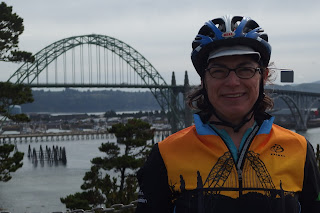
That's the bridge into Newport behind me.  Notice how it is also on my jacket?
I was in the shop so long that I didn't have time to see any of the rest of the town.  It was time to go straight to Rogue's headquarters.  At HQ, they provided us with a tour of the brewing area as well as the museum, whiskey making area, and the new cooperage (barrel making shop).  All that was followed by lunch in their restaurant including a special brew for the tour riders made by their brew master John Meier, also a rider on the tour.

"Dead Guy" is one of Rogue's biggest sellers.  It has an entire alley unto itself in the brewery.
That's me and Bob at Rogue.
Brew meister John Meier
Mary and Cap'n Pete (Pete Saylor) at Rogue.
From Rogue it was a short 23 mile ride to Yachats (pronounced ya-HOTS).  It misted on us most of the way there plus a significant head wind.  Head wind is like a climb that never ends.  The last 1.5-2 miles it really rained.  This was the opposite of last year's ride where we had lovely conditions and bright, shining sun.

Filling kegs at Rogue.  Business didn't stop because of our visit.
After arriving, I took advantage of the sports massage services.  (They use a Thai style massage.)  I felt a lot looser afterward.  Often on multiple day rides my neck and upper back get quite tight and sore.  My quads do get tired also, but not as uncomfortable as my neck.

Despite the good massage, I was feeling very cold so I also had a quick dip in the hotel's hot tub, which made me feel much warmer.  The rain was on and off the rest of the afternoon and expected to be so overnight as well.
None of the campers had set up a tent due to the weather.  The plan was for us to move the tables out of the dining room after dinner and then sleep there.  Not very glamorous, but warm and dry.  However, Mary and Kim decided to see if there were rooms available.  Interesting that it didn't even occur to me!  They got a suite with a bed and a fold out couch.  We were very snug and our cycling clothes got dried out over the heater vents.

Stats:
I didn't get the Garmin turned on.  About 23 miles total.


Saturday, September 19, 2015

PCC Day 6

On our final day we woke up to cold but clear weather.  We left Port Orford by 8 to ensure everyone would be at Gold Beach by 11 am.

I think the stretch between Port Orford and Gold Beach is one of the most beautiful of the ride.  A good portion of it is along the cliffs looking at the ocean.  The Oregon coast has rock structures known as haystacks, which make things more dramatic with the crashing waves.

The parts that weren't looking out at the ocean are fern filled forest and a tiny bit of grassland where a fee cows were grazing.  It was a relaxing ride with not very much climbing.

At Gold Beach we had the option of going on a 2 hour jet boat ride on the Rogue river.  Most of us chose to do it and had a good time.

The boat, to be honest, was pretty noisy but the advantage of that kind of boat is that they need only 6 inches of water to be able to travel.  We watched recreational fishermen on small boats looking for salmon and did see a large catch on the way back.

We also saw egrets, their nests and the nests of eagles, a seal or two, wild grapes growing up a tree, and lots of rocks, trees, and plants.  Sitting still with the engine off, it was extremely peaceful and lovely.  (All the pictures I took came out terrible, sorry.)
 
Upon our return to land, we continued the ride right where we left off.  There was some climbing shortly after leaving Gold Beach, but nothing worse than our Wednesday night training rides up Old Tunnel Road and Grizzly Peak Blvd.

From Gold Beach to Bookings is also a lovely stretch.  More beautiful, sunny beach views, forest, and creeks.  

There were some significant rolling hills as we approached Bookings.  They were challenging at the end of the day at the a full week of cycling, but still manageable.

We rode to the southern end of town to get to the finish line.  It was great fun to roll up under a balloon arch, receive a medal, and have my picture taken like a celebrity.  There was music, champagne, cheering and plenty of cow bells ringing.
I can't turn this photo right side up.  It is me with Allison and Jennifer at the end of the ride.  Allison and Jennifer work at the Arthritis Foundation.  They organized the tour (with others) and worked very hard all week to make sure everything went well.


This was much more leisurely than last year when we had to hurry directly to Brookings to arrive by noon, followed by a hasty lunch, grabbing luggage, and jumping various buses headed all directions.  After a fair amount of feedback from riders about how that arrangement was too rushed and chaotic, it was changed this year to have the whole day to arrive in Brookings with a party at the end and one more night with the gang before returning home.

After all the riders came in, there was a band that played for several hours and one last meal together.
What a week!


The band that played for our last evening together.
Stats: 
58.1 miles
3,466 feet of elevation gain

Thursday, September 17, 2015

PCC Day 5

We started today dry, but with a forecast for rain most of the day, so I definitely put on the rain booties as well as a jacket before I left camp.  I skipped the rain pants because the temperature wasn't very low and I didn't want to sweat too much.

I was the last one out of camp again because everyone left early.  They were scared to be late for our 8:45 a.m. date with the North Bend police.  We had to ride about 12 miles and gather just north of the bridge into North Bend so that two police officers could give us an escort across the bridge.  The nature of this bridge and the time it day we would cross were not conducive to our safety.

After a number of non-rainy miles, I was feeling pretty warm and thought I made the wrong decision about my outerwear, however, it started to rain and then quickly got much harder.  I pulled in at our meeting point and huddled with some others under an overhang, but it did stop raining shortly after.
Waiting for the police escort across the bridge.
Daniella with one of our police escorts.
The bridge crossing went well and we continued through town with light off and on rain  and headed to Coos Bay.  Marking the route had been even more challenging than for the previous day.  Even the chalk paint wasn't holding up well to the conditions, so volunteers and staff were stationed at key areas to make sure we didn't miss any important turns.

At our first rest stop in Charleston, I took my rain jacket off because I knew we were about to do a major climb and it would be too hot, besides it seemed to have stopped raining.  

Our big climb was called the Seven Devils.  There are 7 hills to climb.  It feels like more, due to some false tops, but if you look at an elevation chart, you can see the seven peaks.

Sure enough, just past the first devil, which is one of the harder ones, it started raining, and not just a little bit.  I pressed on, wondering if I should pull over and get my rain jacket and pants out, but I went ahead without them.  Around the time I completed the 3rd devil, the rain eased up and then mostly stopped.
Each devil is spray painted with the number at the top of the peak, but the 5th devil is tricky.  There are a few climbs which make you think you must have reached the summit, only to find that there is no number on the pavement.  When you do see number 5, it is a relief because that means only two are left.  When you reach the 6th devil, you find out that you were tricked and THAT is really the top of number five!  Not a funny joke even if "HA HA HA HA" is painted there.  Which again leaves two more devils.


Bob and I did some picture taking between devils #6 and 7 (below).  The sun was starting to come out and causing some mist/fog.  It was great to get to #7.  Following that, there is a plateau before the downhill portion.  I stopped to take a picture of some rare forest gnomes and also put on my jacket for the downhill part.  I figured that since I was all wet from the earlier rain I would be freezing when the wind from going down started.  Wrong.  It wasn't cold at all.

Some well earned fooling around near the top of Seven Devils.
 
Gnomes are lucky, right?

At the top.

After the downhill, there is some meandering through some lovely forested areas and rolling hills that led back to 101.  We were back on the highway for a relatively short time before taking a side road and rolling into Bandon for rest stop #2 (and lunch at the Crab Shack).
Views as we exited Bandon.

Bandon.

Bandon.
It seemed the sun was ready to stay out at that point, which was great.  It continued all the way to our camp in Port Orford.  There was a fair amount of head wind with the sun, but much better than rain.

We made our way back to 101 and continued all the way down it to Port Orford.  While on the highway, I spotted a piece of art/statement about trash.
Trash eagle.
Our camping spot in Port Orford was in a different place that last year.  I knew it was on the far side of town, but as I saw the city limits sign and had not seen any arrows for quite a long time, I got concerned that I had some how missed the turn.  I stopped and called in to find out, but if I had just ridden another foot, I would have seen the arrow telling me where to go.  Oh well, better safe than sorry.

We fell asleep to the sounds of waves rolling in.
View near our camp.
Stats:
73.0 miles
3,138 feet of elevation gain

PCC Day 4

For day 4, we had rain on and off most of the day.  I was grinding away in it for the first 25 miles or so before there was a break.  The rest of the time it was still wet, but it was only mist or spray from vehicles.  At the first rest stop I had to wring out my socks because I took a risk and didn't put on my rain booties before leaving in the morning.  Everyone left early to try to beat the rain and Mary, Kim and I were the last ones in camp, so I tried to save time and hope for good weather.  Oh well.

I did put the booties on after wringing out my socks, but if I could have seen into the future, I probably wouldn't have bothered at that point. The worst was over.
Its me at the rest stop just after wringing out my socks.  We were drawing poker hands to see who would win a prize.  My full house wasn't high enough.
Because of the wet weather, the route marking was difficult.  Markings usually used on these kind of events are arrows that have adhesive on the back, but neither those nor spray chalk, another common method for marking, would stay on the ground.  Fortunately, the route was easy to follow as it was straight down 101 to Lakeside.  

Normally, there is a scenic bypass that turns off the highway a little before town and winds up a hill, past a lighthouse, and then in to town, but Elliott, who marks the routes, felt it was better to get into town via the more direct route based on the forecasts available at the time he had to go out and mark it.

Before this trip started, a couple of people asked if we would be getting that great welcome in Lakeside, like last year.  I am happy to tell you that we did.  There were people from town on the main street lining the route and waving us in (perhaps a few less than last year due to earlier rain), the handmade scarecrows were also out, and the most favorite of the riders, a huge array of homemade cookies waiting for us.

You can't tell, but the clothes say "Welcome to Lakeside."  It was super windy and they were hung up high, so this is the best picture I could get.
Anne at the cookie reception.

When I arrived, the sun was coming out and a few others has put up their tents, so I did, too.  I was really happy it would be able to dry out.  It was still quite wet from heavy dew at Otter Crest.  It had stayed in my baggage while in the cozy Yachats hotel.

Wet and cold feet and socks.
I left it to do a bit of laundry, since it is right on premises, and take a shower.  Before I got to the shower, Daniella told me the forecast would be rain over night and into the morning.  As a result, the organizers rented a large house across the street for us to spend the night, so we wouldn't have to pack up in the rain the next morning.  That will really give you a soaking wet tent!  It was really fortunate the house was so close and could sleep so many people because the hotel was booked.

Since the rain wasn't going to come until the evening, I figured my tent could wait another half hour while I took my shower.  Can you guess what happened next?

Yes, the rain started pouring as I was walking away from the showers.  I ran to the tent, but of course it was too late.  I packed my things inside the tent (still dry inside) and took them to the rented house.  I hoped the rain would stop again so I could take the tent down later.

While I was doing all my moving and managing my laundry, one of the other riders, Steve Overman, moved my tent under an awning so it could dry out before packing it.  He had done the same for his tent; just pulled the stakes out and picked the whole thing up and carried it.  

Thanks to Steve for looking out for me!  My tent didn't get 100% dry, but it was the driest it had been since waking up the first morning on the baseball field in Astoria.

The rental house was quite nice, with its own washer and dryer, so I was able to get my laundry all the way dry, too.  At least 17 people stayed in the house.

Bikes on the rack in camp at Lakeside

Me and Kim with one of the scarecrows around town.

Stats:
58.4 miles
3,082 feet of elevation gain

Monday, September 14, 2015

PCC Day 2

We began the morning hearing that the was a 60% chance of rain in the areas we would be traveling through.  In the end, we only got a few drops, but we did go through areas that had had rain before we arrived.  Apparently, Wednesday is the day we need to look out for.

Based on the forecast, I pulled the rain gear our of my luggage.  Since it was cold but not yet wet, I wore the jacket and stowed the pants.  I also had on arm and leg warmers and still felt cold until after we had gone over a number of rolling hills.  As the climb over Cape Lookout was nearing, I took off the jacket, but otherwise it stayed cool enough that I kept both the arm and leg warmers all day.  Mr. Incredible was waiting for all of us at the top of the climb.
With Mr. Incredible.

We did most of our riding on smaller highways, away from 101: Three Capes Scenic Route south of Tillamook which took us from Netarts Bay through Cape Lookout State Park and then Pacific City
We had our first rest stop in Pacific City.  I arrived with very cold hands, so I got a hot chocolate at the cafe across the street.  It felt good and tasted good, too!

Cape Lookout area.  Photo by another rider.
After leaving the rest stop, one of the side roads we took was Slab Creek Road and connecting with N. Old Scenic Highway 101 (the former 101, now replaced by a modern highway).  It was a bit of an extended climb, but not bad.  The roads were wet from a previous rain, so I played it cautious on the down hill which meant that it wasn't as much fun as it could have been.  Another advantage to taking it easy on speed (besides keeping upright) was that it prevented me from getting too cold.

At the end of the road we had a second rest stop and I had lunch at the cafe there Otis'.  Great cooked from scratch good, including pie.  I got one of the last pieces of marionberry pie.  Yum!  Marionberries are the most common blackberry cultivar,[2][3] accounting for over half of all blackberries produced in Oregon (from Wikipedia).
Otis Cafe.  Named after the town, not a person.
Bob and Linda inside the cafe.
We rejoined 101 and had a nerve jangling ride through Lincoln City.  Heavy traffic, not much shoulder, and not cyclist friendly at all.  I was happy to get to the outskirts of town.  We went around much of Lincoln City last year but I understand that we couldn't this year due to construction.

Following that, I stopped at Depoe Bay to see if I could see any whales.  I didn't, but Mary and Kim, who came along later did see some spouting.

After Depoe Bay, it was only a handful of miles to the turnoff to Otter Crest.  The road in to the hotel is a climb, but manageable even after more than 70 miles.

We experienced extreme winds here last year, but it was calm today.  Much easier to put up a tent that way.

 
View from our bluff at Otter Crest.

Stats: 
73.62 miles
3,915 feet of elevation gain

Sunday, September 13, 2015

PCC Day 0

People from Oregon and Washington (and one from New York) joined us today.  We left the hotel in a van and headed to Astoria.  There was a significant temperature drop.

Our home for the night was a baseball field at the end of town.  We set up our tents, got our bikes ready, and then headed out for a welcome dinner. 
I realized after dinner that I forgot the holder for my bike computer. It is sitting at home on my spare bike that I was using while my regular bike was being shipped to Oregon.  Oh well.

We get started tomorrow at 8:15 am.

Mary in the foreground.  View from the Astoria Yacht Club where we had dinner.
Design in the floor of the yacht club.

Tents on the field.

PCC Day 1

We had a noisy night next to the barking sea lions, but it wasn't too bad.  I didn't sleep well but I don't think it was the sea lions.  In part, it was because I was too hot.  I put too many clothes on before going to bed.

After breakfast, which was a very tasty breakfast burrito, we went just down the street to a Rogue Public House for photos. After pictures there, we hit the road out of town, led by John and Steve.  John is the brew master at Rogue and Steve is the captain of team Inbetweenie.
Rogue Public House was our starting point.

Although overcast, the weather was warn enough that I didn't put on any arm or leg warmers, which is practically a miracle me, especially considering I was getting dressed at 6:30 am.

After leaving Astoria, we rode for a while and then came into Seaside.  In Seaside we had a lovely ride along the car-free promenade, right on the water.

Somehow I missed the first rest stop in Canon Beach and just kept going.  There was some rolling and climbing, but nothing too strenuous.

One of the major challenges of the first day of riding is the Arch Cape Tunnel.  It is a narrow with limited to no shoulder.  To improve safety for cyclists, before entering tunnels there is a button to press which activates flashing lights on yellow signs to alert cars that cyclists are present.  Cars are supposed to slow to 30 mph. I'm not sure how many do.  Also, the lighting isn't great and the noise level is terrible.

Last year, I must have lucked out because I can't really remember having a bad experience or hardly any cars.  This year, not so lucky.  Quite a few cars went by, each direction.  It was a bit hair-raising, especially with the constant noise.  The one good thing I can say is that the tunnel isn't that long.

Lights and sign outside tunnel
This is a picture taken by another cyclist of the inside of the tunnel, showing the lack of shoulder.

 I saw the second rest stop because Ginger was at the curb with pom poms.  The stop was at a restaurant, but it was only 11:30 in the morning and I wasn't very hungry, so I took a PB&J half sandwich and continued after a short break.

Besides not being very hungry, I had an ulterior motive to eating light.  I planned to stop at the Tillamook cheese factory when I got to town and eat their samples.  I knew that would be at the end of the ride, in about 20 or 25 miles.

Just down the hill from the rest stop was a turn off 101 and on to some back roads through farming areas.  Last year we stayed on 101 the whole time, but on Sundays the traffic is fairly heavy, so one of the route changes this year was to get off the highway for a while.  It was definite improvement and the scenery was lovely; peaceful and relaxing.  The "detour" was 14 miles and then we returned to 101 to get into the town of Tillamook, riding along Tillamook Bay and enjoying the shining sun.

Relaxing cows on our 101 detour.
Sheep on the detour.
We camped at a different place this year, closer to town and across the highway from the cheese factory.  I arrived about 1:30 pm, which gave me plenty of time to take a shower and put up my tent before going to taste the cheese.
The factory was mobbed with people and there wasn't much going on in the factory to observe, but I did get a few samples.


Tillamook Bay

Cheese factory
Stats:
66.5 miles
2,928 feet of elevation gain

Friday, September 11, 2015

People's Coast Classic (PCC) Bike Tour for the Arthritis Foundation Day 00

9/11:  Today was a travel day.  I did some last minute packing, went to the ATM, packed a lunch and then set out on BART.  I sent my bike ahead to Newport Bikes about a week earlier and a few days ago sent my camping gear in the car with Jennifer from the Arthritis Foundation's San Francisco office, so I only had one rolling suitcase with me.

This was the first time I've used the connector between the coliseum station and the Oakland airport.  It was very easy to use and worked well.

Six of us were on the flight.  It wasn't a very  big plane.  In fact, it had propellers.  First time for me!
We arrived in Portland, collected our stuff, which included 4 bikes in boxes and cases plus various luggage and took a shuttle to the hotel. 

Kim and I got a good nap in before meeting the group for dinner.  We had a great time at the Kennedy School, a former elementary school that has been transformed into a hotel, restaurant, bar, and movie theater.  I'd like to come back and spend some time here.

That's it for today.  Tomorrow we will take a bus at midday to Astoria and start camping.

Propeller plan we took from Oakland to Portland.
Cycling enthusiasts in Oregon can have a license plate that shows their support of cycling.

Mary and Kim collecting their bikes at the oversized luggage claim.


Saturday, September 5, 2015

Training Ride 9/5: Marin Loop

This is the traditional final group training ride before taking off for the Arthritis Foundation bike tour.  It is a beautiful route and we had great weather this year!  In my first year we were rained out.
Here we are, ready to start.  Some will do the California Coast Classic, others the People's Coast Classic in Oregon, and a few others were just along for the ride.
We started at the very far eastern end of Lucas Valley Road at McInnis Park Golf Center, a public golf course and ball field.  Actually, the street is called Smith Ranch Road at this location.  It changes its name to Lucas Valley after it passes 101.  We continued west all the way to the other end Lucas Valley Rd.  The sun was shining and it was fairly warm in the sun, but on the latter part of the road, which is mostly in the shade, it was still cold at that time of the morning. The road winds up and down for about 10 miles.  Much of it doesn't have any shoulder, but as a major cycling route, cars and bikes manage pretty well together.  Lots of lovely scenery, especially after passing the the mostly residential areas.

We regrouped in Nicasio.  I took my leg warmers off there and never missed them. We headed out together to the Pt. Reyes-Petaluma Highway.  Those doing the shorter route went left.  The rest of us went right to Hicks Valley Road.  Hicks Valley Rd. is a fairly quiet place with mostly dairy farms and a very small elementary school.  From there, we got even more rural on Petaluma-Marshall Road.  

The Marshall Road is one of my favorite sections of this ride, which has many great parts.  The condition of the road isn't great, but it is very quiet and restful.  It rolls up and down for about 8 miles with cows here and there and some sheep, too if you know where to look.  

At the base of the Marshall grade I waited for some of the others to join me.  While I was waiting a couple of guys drove up on an ATV pulling a small trailer with hay for the cows in the field behind me.  They heard or smelled them coming before I did.  They started mooing like crazy before I could tell what the fuss was about.  When the men entered the far side of the gated area, those cows high-tailed it over there for lunch.
Mailboxes on Marshall-Petaluma Road.
We headed up the climb.  It isn't that high, but the grade can be challenging, some of it is 10%.  I coughed most of the way up.  Something must have been blooming that affected my allergies.  I was rewarded with a great view at the top.  Almost no clouds at all.

View of Tamales Bay from atop the Marshall grade.

I headed down the other side to highway 1.  The ocean influenced air helped to get rid of that itchy feeling in my throat, but it didn't go away completely until the end of the ride.  

We headed south on highway 1, Tomales Bay sparkling beside us.  Despite being a holiday weekend, the car traffic wasn't too heavy.  We rolled up and down the highway to Pt. Reyes Station for our lunch stop.

After lunch we took Pt. Reyes-Petaluma highway to Platform Bridge Road so that we could connect with Cross-Marin trail and into Samuel P. Taylor park.   We took a lovely path that had been converted from a defunct railroad line.  We rode through a forested area amongst redwoods, ferns and many other flora. When the paved trail ended, half of us continued on the unpaved trail and half got on Sir Francis Drake Blvd.  The unpaved trail was about 3 miles.  It intersected with Sir Francis Drake again and we got back on the pavement.  A few miles down we turned on to Nicasio Valley Road where we met the half who took the paved road the whole way.
On the unpaved trail with Mary Arnone.

We went another 8 miles or so to Lucas Valley Road and took that all the way back to the starting point.

Stats:
72.29 miles
3,240 feet of elevation gain

Training Ride 9/2: Wednesday Night Ride

I met Mary at her house and we started our usual ride.  I was somewhat overdressed with both leg and arm warmers on.  When I changed at work, I was guessing at the weather by looking out the window and it didn't look very good.  I was also on my old bike with the upright handlebars. We have shipped my usual bike to Oregon the day before for the tour.

I considered taking off my extra items to cool off a bit, but I didn't feel like stopping to do it.  It wasn't too long, however, before I started to appreciate all the items I had on.  The wind came up and was cold.  Before we got to the top of Old Tunnel the clouds had come in and it was getting colder. 

Plaque on Old Tunnel Road showing where the old tunnel used to be.

Another plaque with more information about the tunnel.  Do you want to know where these are?  Let me know and we'll ride up there some time.

 We had a miscommunication with Kim and accidently missed her at Peets.  She was on her way up Old Tunnel so we rode back to meet her and then up to the top again.  We continued together up Grizzly Peak Blvd.  The light was fading due to it being a bit later than usual because of the meeting place mix up, the fog, and the sunset getting earlier every day.  

On the way down Grizzly Peak after steam trains, I ran over something in the road and got a flat. I pulled over a little above Centennial.  I was very happy to change the flat quickly, but I couldn't get wheel aligned right.  I kept rubbing on the brake. 

When it seemed that I wasn't going to be able to get it right and the light was fading, Mary called her husband to come pick us up.  After all the arrangements were made, I did fix it but it was nearly dark.  By that time I was getting pretty cold with the wind blowing on my sweaty clothes so I put on my jacket.   

While we were waiting, I saw some guy walking toward us in the darkness.  I was not alarmed but I was keeping an eye on him because it was an odd place to be walking, especially at that time of night.  Of all things, it turned out to be my boyfriend John!  On his way home from work he had passed us standing in the pull out waiting.  Even in the low light he could recognize our orange Arthritis Foundation jerseys.  He parked a little further ahead in the next shoulder and walked back to us when we didn't ride past him.  What a coincidence!

Since John was there and happened to have his bike rack, I went with him. While we were loading up, Mary's husband arrived and picked up Mary and Kim.  By the time I got into John's car, I was feeling extremely cold, especially my hands, due to the half finger gloves. 

John took me to Mary's house, where my car was and I drove home.  It felt like it took forever for my hands to warm up.  I had to get under a wool blanket once I was in the house.

Stats:
12.44 miles
1,922 feet of elevation gain.  As Mary pointed out, we had done all the climbing anyway, so skipping the down hill and flat miles wouldn't make a big difference.

Training Ride 8/30: Calaveras Loop

In previous training seasons I have done more rides that were on consecutive days to be prepared for a week of days in the saddle when on the bike tour.  I haven't done as much this year because it really sucks up most of the weekend and makes it hard to get anything else done.  However, I decided that as the end of this season's training was coming near, I needed to add a consecutive day of riding.  So, despite all the climbing the day before for Big Basin, I joined the California Deaf Wheelers for their monthly road ride on 8/30. 
Group picture before take off.
We met at the California School for the Deaf in Fremont and then headed through some residential streets to connect with Niles Canyon Rd.  It was much nicer than going down Mission Blvd., which is how I have gotten on to Niles Canyon with all the other groups I have ridden with. 

When we turned on to Niles we ended up behind a very large group on same route, Avila cycling.  I couldn't find any listing for them when I did a Google search.  I wish I knew more about them and what their event was.  Being behind this large group on such a narrow road, we were slowed down.  We regrouped at corner of Niles and Calaveras Rd, which allowed the Avila group to get ahead of us and spread out a bit.

Our group of about 10 people, turned on to Calaveras.  Calaveras rolls a little for a few miles and then begins a gentle climb.  I was worried that I'd be toast on the climb due to all the climbing the day before, but I took it slow and steady and everything was fine.  The guys on this ride are mostly faster than me, so I found most of them waiting in the shade at the false top where the dam construction entrance is.  It was pretty warm out and still a bit humid from the day before.

After regrouping, we continued on to the down hill and rolling sections.  There was a nice cool breeze once past the false top.  We met again at the top and then went down "the wall" and into Milpitas. 

I don't really know my way around this part of the Bay Area and there was no route sheet, so I tried to stick close to at least one other person at all times so I wouldn't miss a turn.  We took a variety of residential streets until we reached Mission Blvd. 

When I got to Mission, I'd gotten dropped by the people in front of me, but I knew someone was behind me, so I waited for him to arrive and tell me which way to go.  I thought it would be left, but it turned out to be right.  Good thing I waited.  After thinking about it for a while as I rode on, I realized I should have known to go right from the several times I have been this way with other groups.  Oh well.

We continued on Mission Blvd, where we found the others waiting for us near Ohlone College.  We continued together in a sort of pace line to Stevenson Blvd. and turned left.  We were almost back to the school and the end of the ride when our ride leader got a flat just before the last corner (Gallaudet Dr.)  He changed the tire quickly and we went around the corner and into the school's parking lot.  It was a nice warm day, but not too hot.  Because this was a relatively fast group, we got done before noon, which was great for me.  I had a bunch of chores waiting for me at home.

Stats:
38.88 miles
1,896 feet of elevation gain